


A question for the pros
TxMarti
11 years ago
Sort by:Oldest
Comments (12)
Related Stories
WORKING WITH PROS12 Questions Your Interior Designer Should Ask You
The best decorators aren’t dictators — and they’re not mind readers either. To understand your tastes, they need this essential info
Full Story
WORKING WITH PROS10 Questions to Ask Potential Contractors
Ensure the right fit by interviewing general contractors about topics that go beyond the basics
Full Story
WORKING WITH PROS9 Questions to Ask a Home Remodeler Before You Meet
Save time and effort by ruling out deal breakers with your contractor before an in-person session
Full Story
MOST POPULAR8 Questions to Ask Yourself Before Meeting With Your Designer
Thinking in advance about how you use your space will get your first design consultation off to its best start
Full Story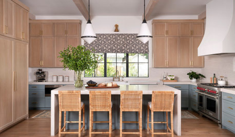
KITCHEN LAYOUTSThe Pros and Cons of 3 Popular Kitchen Layouts
U-shaped, L-shaped or galley? Find out which is best for you and why
Full Story
WORKING WITH PROSWorking With Pros: When You Just Need a Little Design Guidance
Save money with a design consultation for the big picture or specific details
Full Story
DECORATING GUIDESWorking With Pros: When to Choose Full Design Services
Whether you want a single room or a whole house done, the maximum service level means the least work for you
Full Story
DECORATING GUIDESWorking With Pros: When a Design Plan Is Right for You
Don’t want full service but could use some direction on room layout, furnishings and colors? Look to a designer for a plan
Full Story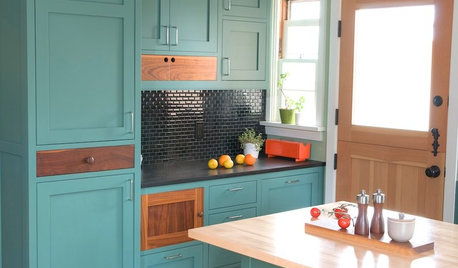
MOST POPULARFrom the Pros: How to Paint Kitchen Cabinets
Want a major new look for your kitchen or bathroom cabinets on a DIY budget? Don't pick up a paintbrush until you read this
Full Story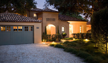
REMODELING GUIDESGravel Driveways: Crunching the Pros and Cons
If you want to play rough with your driveway, put away the pavers and choose the rocky road
Full Story


Yardvaark
gyr_falcon
Related Professionals
West Milford Landscape Architects & Landscape Designers · Accokeek Landscape Architects & Landscape Designers · Clark Landscape Architects & Landscape Designers · Graham Landscape Architects & Landscape Designers · Wakefield Landscape Contractors · Forest Hills Landscape Contractors · Hendersonville Landscape Contractors · Lake Worth Landscape Contractors · Antioch Landscape Contractors · Lauderdale Lakes Landscape Contractors · Grand Rapids Decks, Patios & Outdoor Enclosures · Miami Decks, Patios & Outdoor Enclosures · Riverside Decks, Patios & Outdoor Enclosures · Winchester Center Stone, Pavers & Concrete · Thousand Oaks Swimming Pool BuildersTxMartiOriginal Author
laurell
TxMartiOriginal Author
laurell
TxMartiOriginal Author
cearbhaill (zone 6b Eastern Kentucky)
Yardvaark
TxMartiOriginal Author
TxMartiOriginal Author
Yardvaark